Dev Summit Day Two
This morning was the Keynote Session. They started with an animated video about "how does our data feel." Um....
The winners of the dodgeball competition get free entries into next years Dev Summit.
I forgot to mention that upon checkin, they did not give an encyclopedia of marketing material and schedule. Nothing but my name tag and a notebook. They wanted everyone to download an app. The app was glitchy but ok. Come 2 o'clock, the plugs were jampacked with people fighting to charge their phones. I deleted it. I was glad I printed a copy beforehand and happened to bring it. Thank goodness. I think the app is a fail.
The keynote speaker was Joseph Sirosh, the Corporate VP of Artificial Intelligence and Research at Microsoft.

His speech was more of a marketing ploy. He said AI is exciting because it's the opposite of natural stupidity. He wants to infuse AI into every Microsoft product. He tried to demo one of his projects ON AN IPAD...
Someone asked him what AI isn't good for? He said that AI facial recognition is biased. AI is software. Software needs debugging. It was built off pictures on the internet. Pictures on the internet are predominantly white people. AI can't recognize dark skin.
This time the front sofas were stuffed with people! I snagged this interesting side chair. Twas quite comfy.

My first class was Sharing 3D Content with Scene Layers. Data availability is driving the demand for new GIS experiences. We need visually compelling maps that are deep and smart. ESRI has plans for a Mobile Scene Package this year sometime. Woo-hoo!

Every time the speaker changed slides, I would hear at least 20 camera clicks. After a few slides, I figured I should join them.


Lunch today wasn't worth a picture.
I found some colleagues that said a place called Hadley's makes divine Banana Date Shakes, and are a must for every Dev Summit. Apparently they go every day. It is 19 miles from the conference center, so one of them makes sure to drive each year so they can go. And away we went. I am so surprised to report that they were divine!
The next class was "Making Pop-Ups Pop," and was published at the wrong time...pretty much everyone showed up too late. The presenters promised to upload their slides so we could see it eventually.
Next was "Building Your Own Widget with ArcGIS API for JavaScript." The class was stuffed with people, and more than half left within the first 15 minutes. It was not an intro class. They talked about sass, nodes, aria, hover, first-child, BEM, and more.

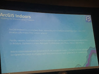
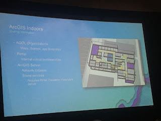
ArcGIS Indoors is coming this year.This is a new term being used and developed in the last 9 months, and is a merge of a few different programs. It uses an ArcGIS Indoors Info Model (AIIM). AIIM's are managed and authorized in Pro. There is a new tool called "import CAD to GIS." They use POIs for routing. The network is built of walking latice to create pathways. It'll give turn by turn directions, routing through network analyst. You create a mobile map package, upload to portal, the network is embedded in the map package and stored on device, and a person orients indoors using their phones compass.
I think this will be cool. Although most of the work has been done already for the Horrocks building in other ways, the routing indoors portion will be neat, and the ability to push to mobile is awesome.


Our next team building activity should be VR dodgeball:

My last class was "Controlling the Chaos: Establishing Best Practices for Python Scripting."
The don'ts:
Happy GIS-ing!
Lindsy Hales Bentley
https://youtu.be/8GawEOBLb4Y
The winners of the dodgeball competition get free entries into next years Dev Summit.
I forgot to mention that upon checkin, they did not give an encyclopedia of marketing material and schedule. Nothing but my name tag and a notebook. They wanted everyone to download an app. The app was glitchy but ok. Come 2 o'clock, the plugs were jampacked with people fighting to charge their phones. I deleted it. I was glad I printed a copy beforehand and happened to bring it. Thank goodness. I think the app is a fail.
The keynote speaker was Joseph Sirosh, the Corporate VP of Artificial Intelligence and Research at Microsoft.

Someone asked him what AI isn't good for? He said that AI facial recognition is biased. AI is software. Software needs debugging. It was built off pictures on the internet. Pictures on the internet are predominantly white people. AI can't recognize dark skin.
This time the front sofas were stuffed with people! I snagged this interesting side chair. Twas quite comfy.

My first class was Sharing 3D Content with Scene Layers. Data availability is driving the demand for new GIS experiences. We need visually compelling maps that are deep and smart. ESRI has plans for a Mobile Scene Package this year sometime. Woo-hoo!
- The world elevation surface in Pro is 24 meter accuracy.
- Scene layers are a .I3S.
- Currently there are 45,000 public and privately shared 3D layers.
- There are 4 types of layers
- 3D objects
- Points
- Integrated Meshes
- Point Cloud
- Pro 2.1 includes an interactive analysis with viewshed.
- There is an IOS SDK sample app to download.
The teacher was adamant that you can't navigate underground in an online scene, and that ability is coming 2019. And "hackers can get around it." Boom.

Every time the speaker changed slides, I would hear at least 20 camera clicks. After a few slides, I figured I should join them.


Lunch today wasn't worth a picture.
I found some colleagues that said a place called Hadley's makes divine Banana Date Shakes, and are a must for every Dev Summit. Apparently they go every day. It is 19 miles from the conference center, so one of them makes sure to drive each year so they can go. And away we went. I am so surprised to report that they were divine!
The next class was "Making Pop-Ups Pop," and was published at the wrong time...pretty much everyone showed up too late. The presenters promised to upload their slides so we could see it eventually.
Next was "Building Your Own Widget with ArcGIS API for JavaScript." The class was stuffed with people, and more than half left within the first 15 minutes. It was not an intro class. They talked about sass, nodes, aria, hover, first-child, BEM, and more.
ArcGIS Indoors is coming this year.This is a new term being used and developed in the last 9 months, and is a merge of a few different programs. It uses an ArcGIS Indoors Info Model (AIIM). AIIM's are managed and authorized in Pro. There is a new tool called "import CAD to GIS." They use POIs for routing. The network is built of walking latice to create pathways. It'll give turn by turn directions, routing through network analyst. You create a mobile map package, upload to portal, the network is embedded in the map package and stored on device, and a person orients indoors using their phones compass.
I think this will be cool. Although most of the work has been done already for the Horrocks building in other ways, the routing indoors portion will be neat, and the ability to push to mobile is awesome.


Our next team building activity should be VR dodgeball:

My last class was "Controlling the Chaos: Establishing Best Practices for Python Scripting."
The don'ts:
- inadequate documentation
- scripts running on local machines
- different versions
- unclear ownership
- variation in script design
- few standards
- prioritizing delivery over all else
Define best practices:
- upgrade old applications
- deployment guidelines
- documentation
- what does it do and why
- creation date
- QA and peer review
- code review
- doc review
- version control
- create a minimum python template
- template to start projects
- uniform structure
- custom python module
- create library for standard method
- write a log
- send an email on interesting events
- access config file
- parse input parameters
- copying data from sde to gdb
These will reduce confusion, improve efficiency. Think about which practices work for our team? Be able to adapt moving forward. It is important to have team buy-in.
For dinner I went to Sherman's.
 |
| Pastrami Latka |
 |
| A monster piece of cake/mouse/cheesecake/mouse/cake. |
Happy GIS-ing!
Lindsy Hales Bentley
https://youtu.be/8GawEOBLb4Y